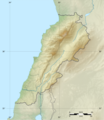
Fayl:Lebanon location map Topographic.png

Túp fayl (993 × 1142 piksel, fayldıń ólshemi: 990 КБ, MIME tipi: image/png)

Bul fayl Wikiqoyma joybarınan hám basqa joybarlarda da qollanılıwı múmkin. Onıń fayl táriypi betiniń sıpatlaması tómende kórsetilgen.

Juwmaq

Camera location33° 50′ 00″ N, 35° 40′ 00″ E Kartographer map based on OpenStreetMap.View this and other nearby images on: OpenStreetMapinfo
Sıpatlama
Deutsch: Positionskarte des Libanon

Quadratische Plattkarte, N-S-Streckung 115 %. Geographische Begrenzung der Karte:

Français : Carte physique vierge du Liban, destinée à la géolocalisation.

Projection equirectangulaire, N/S stretching 115 %. Limites géographiques de la carte:

English: Location map of Lebanon

Equirectangular projection, N/S stretching 115 %. Geographic limits of the map:

  • N: 34.9° N
  • S: 32.8° N
  • W: 34.8° E
  • E: 36.9° E
Sáne
Fayl deregi

Topographic background map: Own work

Avtor Vivepat and NordNordWest
Ruqsat
(Bul fayldan qayta paydalanıw)
Attribution and Share-Alike required
Басқа нұсқалары

Licenziyalaw

Мен бұл туындының авторымын, келесі лицензия аясында бұны жариялаймын:
GNU head Permission is granted to copy, distribute and/or modify this document under the terms of the GNU Free Documentation License, Version 1.2 only as published by the Free Software Foundation; with no Invariant Sections, no Front-Cover Texts, and no Back-Cover Texts. A copy of the license is included in the section entitled GNU Free Documentation License. тек 1.2 
GNU head Permission is granted to copy, distribute and/or modify this document under the terms of the GNU Free Documentation License, Version 1.3 or any later version published by the Free Software Foundation; with no Invariant Sections, no Front-Cover Texts, and no Back-Cover Texts. A copy of the license is included in the section entitled GNU Free Documentation License.

w:en:Creative Commons
atribut birdey shártlerde taratıw
Bul fayl Creative Commons tiykarında licenziyalanǵan Attribution- Share Alike 3.0 Unported licenziyası.
Siz bossız:
  • Bólisiw – Jumıstı nusqalaw, tarqatıw hám uzatıw
  • Remiks qılıw – Jumısqa beyimlesiw
Tómendegi shártler tiykarında :
  • atribut – Siz tiyisli kredit beriwińiz, licenziyaǵa siltemeni usınıwıńız hám ózgertiwler kiritilgenligin kórsetiwińiz kerek. Siz bunı hár qanday aqılǵa say jol menen etiwińiz múmkin, biraq licenziar sizdi yamasa siziń paydalanıwıńızdı maqullawın usınıs etetuǵın tárizde emes.
  • birdey shártlerde taratıw – Eger siz materialdı remiks qılsańız, ózgertseńiz yamasa oǵan tiykarlansańiz, óz úleslerińizdi túp nusqadaǵı sıyaqlı birdey yamasa uyqas licenziya tiykarında tarqatıwıńız kerek.
Siz ózińiz qálegen licenziyanı tańlawıńız múmkin.

Captions

Add a one-line explanation of what this file represents

Items portrayed in this file

súwretlengen obiekt

16 Iyun, 2012

coordinates of the point of view ағылшын тілі

33°49'59.999"N, 35°40'0.001"E

media type ағылшын тілі

image/png

checksum ағылшын тілі

1a6c8526df2cc76a4a21b45961d01b3e722f0500

data size ағылшын тілі

1 013 653 byte

height ағылшын тілі

1142 pixel

width ағылшын тілі

993 pixel

Fayl tariyxı

Aldın bul fayl qanday kóriniste bolǵanın kóriw ushin sáne/waqıt degendi basıń.

Sáne/WaqıtMiniatyurasıÓlshemleriPaydalanıwshıPikir
házirgi06:17, 2017 j. iyunnıń 2206:17, 2017 j. iyunnıń 22 waqtındaǵı nusqanıń miniatyurası993 × 1142 (990 КБ)Vivepatcorrection lat/lon
06:10, 2017 j. iyunnıń 2206:10, 2017 j. iyunnıń 22 waqtındaǵı nusqanıń miniatyurası993 × 1142 (990 КБ)VivepatLattitude error correction
05:59, 2017 j. iyunnıń 2205:59, 2017 j. iyunnıń 22 waqtındaǵı nusqanıń miniatyurası993 × 1142 (990 КБ)Vivepatupdate of the map using the Wikipedia maps conventions
22:12, 2012 j. iyunnıń 1522:12, 2012 j. iyunnıń 15 waqtındaǵı nusqanıń miniatyurası1581 × 1818 (3,35 MB)Dr Brains

Tómendegi dana bette bul fayl paydalanılǵan:

Fayldı global paydalanıw

Tómendegi basqa wikilar bul fayldan paydalanadı:

Bul fayldıń kóbirek global paydalanıw bólimin kóriń.