Fayl:The Portuguese Empire.png

Kórip shıǵıw kólemi: 800 × 407 пиксел. Basqa rezolyutsiyalar: 320 × 163 пиксел | 640 × 325 пиксел | 1024 × 521 пиксел | 1280 × 651 пиксел | 2753 × 1400 пиксел.
Túp fayl (2753 × 1400 piksel, fayldıń ólshemi: 232 КБ, MIME tipi: image/png)

|
This locator map image could be re-created using vector graphics as an SVG file. This has several advantages; see Commons:Media for cleanup for more information. If an SVG form of this image is available, please upload it and afterwards replace this template with
{{vector version available|new image name}}.
It is recommended to name the SVG file “The Portuguese Empire.svg”—then the template Vector version available (or Vva) does not need the new image name parameter. |
Juwmaq
| Sıpatlama |
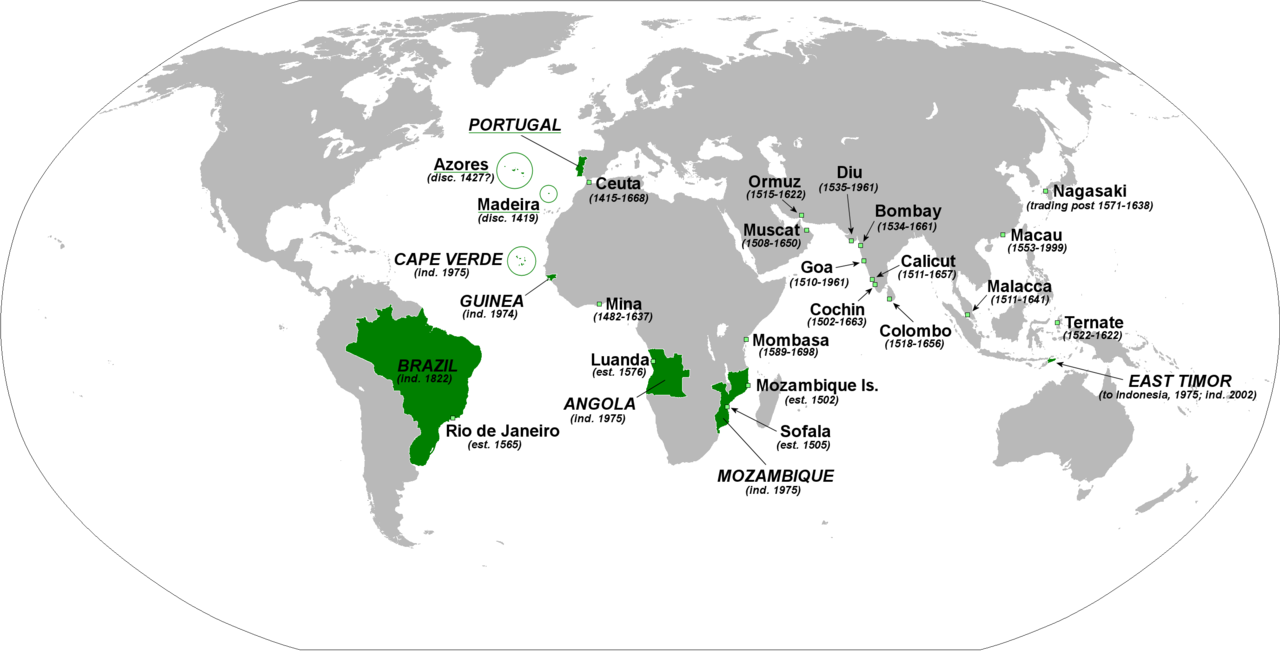
English: The principal forts, trading posts and colonies of the Portuguese Empire (1415-1999).
Abbreviations: disc: date of discovery est: date of establishment ind: date of independence Present-day Portuguese territory is underlined in green. |
| Sáne | |
| Fayl deregi | Óz dóretiwshilik jumısım |
| Avtor | The Red Hat of Pat Ferrick |
Licenziyalaw
| I, the copyright holder of this work, release this work into the public domain. This applies worldwide. In some countries this may not be legally possible; if so: I grant anyone the right to use this work for any purpose, without any conditions, unless such conditions are required by law. |
Fayl tariyxı
Aldın usı fayl qanday kóriniste bolǵanın kóriw ushin kún-ay/waqıt degendi basıń.
| Sáne/Waqıt | Miniatyurası | Ólshemleri | Paydalanıwshı | Pikir | |
|---|---|---|---|---|---|
| házirgi | 01:46, 2018 j. fevraldıń 3 | | 2753 × 1400 (232 КБ) | 42800141 | Removed the state of Acre from the rest of Brazil and the border between Brazil and Uruguay |
| 02:02, 2009 j. yanvardıń 8 |  | 2753 × 1400 (214 КБ) | The Red Hat of Pat Ferrick | lose a few arrows | |
| 02:16, 2009 j. yanvardıń 5 |  | 2753 × 1400 (223 КБ) | The Red Hat of Pat Ferrick | forgot E. Timor | |
| 01:09, 2009 j. yanvardıń 5 |  | 2753 × 1400 (214 КБ) | The Red Hat of Pat Ferrick | Underlines for present day Portuguese territory | |
| 00:49, 2009 j. yanvardıń 5 |  | 2753 × 1400 (214 КБ) | The Red Hat of Pat Ferrick | Arrow for Ceuta | |
| 00:46, 2009 j. yanvardıń 5 |  | 2753 × 1400 (213 КБ) | The Red Hat of Pat Ferrick | {{Information |Description={{en|1=The principle forts, trading posts and colonies of the Portuguese Empire (1415-1999). Abbreviations: est: date of establishment ind: date of independence }} |Source=Own work |Author=[[User:The Red Hat of Pat Ferrick|The |
Fayldıń paydalanılıwı
Tómendegi dana bette bul fayl paydalanılǵan:
Fayldı global paydalanıw
Tómendegi basqa wikilar bul fayldan paydalanadı:
- ar.wikipedia.org joybarında qollanıw
- ca.wikipedia.org joybarında qollanıw
- de.wikipedia.org joybarında qollanıw
- el.wikipedia.org joybarında qollanıw
- en.wikipedia.org joybarında qollanıw
- en.wikibooks.org joybarında qollanıw
- et.wikipedia.org joybarında qollanıw
- fa.wikipedia.org joybarında qollanıw
- fr.wikipedia.org joybarında qollanıw
- gl.wikipedia.org joybarında qollanıw
- id.wikipedia.org joybarında qollanıw
- incubator.wikimedia.org joybarında qollanıw
- it.wikipedia.org joybarında qollanıw
- oc.wikipedia.org joybarında qollanıw
- pl.wikipedia.org joybarında qollanıw
- pt.wikibooks.org joybarında qollanıw
- qu.wikipedia.org joybarında qollanıw
- sc.wikipedia.org joybarında qollanıw
- uk.wikipedia.org joybarında qollanıw
- uz.wikipedia.org joybarında qollanıw
- zh.wikibooks.org joybarında qollanıw